Spicers Mill Farm
Property Owners Assoc.
Menu
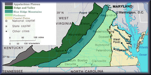
The Piedmont region of Virginia is a part of the greater Piedmont physiographic region which stretches from the falls of the Potomac, Rappahannock, and James Rivers to the Blue Ridge Mountains. The region runs across the middle of the state from north to south, expanding outward to a width of nearly 300 miles at the border with North Carolina. To the north the region continues from Virginia into central Maryland and southeastern Pennsylvania. It encompasses the counties of Loudoun, Fauquier, Rappahannock, Culpeper, Madison, Greene, Orange, Spotsylvania, Louisa, Albemarle, Fluvanna, Goochland, Nelson, Amherst, Buckingham, Cumberland, Powhatan, Amelia, Bedford, Campbell, Appomattox, Prince Edward, Nottoway, Charlotte, Franklin, Pittsylvania, Franklin, Patrick, Henry, Halifax, Lunenburg, Mecklenburg, Brunswick, Stafford, Prince William and Fairfax in Virginia.[1] The Virginia Piedmont is largely characterized by rolling hills and numerous ridges near the boundary with the Blue Ridge Mountains. Lying between the mountain and coastal plain regions, the piedmont region is a naturally diverse landscape.[2] The bedrock is comprised mostly of gneiss, schist and granite rocks at a typical depth of between 2 and 10 feet. These rocks have given the Virginia Piedmont soils which are generally infertile. However, they are much improved through liming and fertilization, and have historically been intensively farmed.[3] The region contains several areas and stretches of land which are of relatively high agricultural value.
website copyright 2013 Spicers Mill Farm Homeowners Association